
NWA Trail Systems
Northwest Arkansas has hundreds of miles of trail, most of them organized into trail systems. Once you understand how those systems work, the whole region suddenly makes a lot more sense.
Bella Vista West · Bella Vista East · Bentonville
What is a trail system?
A trail system is a connected network of trails that share a general area, a set of trailheads, and a name. Instead of one path from A to B, a system is more like a web— dozens of individual trails that link together—which means you can often string together a short stroll or an all-day hike from the same starting point. Each system has its own personality, and locals often talk in systems. Instead of just saying, “I’m going for a hike,” they might say, “I’m hiking at Wonderland.”

NOTE: The map above does not include Osage Park or Crystal Bridges as these aren’t technically considered trail systems.
NWA trails are for hikers, too
Nearly every trail system in NWA is multi-use, which means it was designed from the ground up to be shared by hikers, walkers, trail runners, and mountain bikers alike. That being said, some trails are designated as bike-only, usually because they are downhill/gravity trails where it would be dangerous for hikers and bikers to share the trail.
On a multi-use trail, everyone must yield to keep things friendly and safe—bikers yield to anyone on foot and trail runners yield to hikers. But when in doubt, just step to the side, say hello, and let faster traffic pass.
How to use this page
Below, the systems are grouped by area—Bella Vista (west, then east) and Bentonville—with more cities coming soon. A few of the places we include, like Osage Park and the Crystal Bridges grounds, aren’t “trail systems” in the traditional mountain-bike sense. But each is its own distinct place to walk or hike, with its own trails and character. So for this guide, we include them all as trail systems. Each summary links to that trail system’s own page where you’ll find trailheads in the system, parking information, hiking route, and exactly which specific trails we recommend you avoid as a hiker.
Bella Vista (west side)

Little Sugar
~57 miles · paved + natural surface · Owned & operated by the City of Bella Vista
Bella Vista’s largest network, and the friendliest place to start—nearly 60 miles, nearly all of it hikeable. Beginners have their pick of easy loops: the natural Tweety loop, the quarter-mile paved Bluebird loop, and the part-paved, part-natural Tanyard Creek Nature Trail with its waterfall and suspension bridge. For a step up, Tunnel Vision—the system’s backbone loop—drains well after rain, and its “Sugar Vision” stretch beside Sugar Creek makes a beautiful moderate hike. For a challenge, Danger Will Robinson and Sick-A-More are both excellent—Sick-A-More especially, one of the prettiest trails in the system, with gorgeous views of moss-covered bluffs.
Bella Vista (east side)

Back 40
~47 miles · paved + natural surface · Owned & operated by the City of Bella Vista
The system that put Bella Vista on the map—around 47 miles of hand-cut trail winding through the ridges and hollows on the east side of town, built around the Back 40 Loop. Almost all of it is classic, hikeable cross-country singletrack, and most of it is moderate. For an easy start, the paved Berksdale South and Razorback Greenway offer smooth miles (the greenway rolls with some elevation), Cooper Chapel has pretty paved walks, and Snowbird is a gentle natural loop. For scenery, Pinion Creek Falls sits right off the road, while It’ll Bluff Out—moderate to challenging, with dramatic bluffs and a rain-fed waterfall—and The Ledges reward a bit more effort. Just one trail, the downhill Go Ride, isn’t suitable for hiking; its parallel Flo Ride is the hikeable alternative right alongside. Back 40 also connects into the neighboring Blowing Springs system.

Blowing Springs
~10 miles natural + paved greenway · Owned & operated by the Bella Vista Property Owners Association
A compact, scenic system built around Blowing Springs Park, where the namesake spring and cool rock formations set the tone. About 10 miles of natural-surface trail wrap around a paved greenway that runs up the middle, passing Gear Garden and its food and coffee trucks. Blowing Springs North (at the west end) and Bomb Diggity wind past beautiful rock features, with Bomb Diggity running right along the bluffs, while Mighty Pine runs through tall pines past the old entrance to Wonderland Cave and its stone-building “ruins.” For a moderate hike, Blowing Springs South and Low Ride are both excellent. The system also connects into the neighboring Back 40 and Wonderland trails.

Wonderland
~6 miles (5 hike-friendly) · paved greenway + natural surface · Owned & operated by the Trailblazers & the City of Bentonville
A small, welcoming system—about 6 miles of trail, 5 of them hike-friendly—and one of the area’s best spots for beginners. Several parallel, low-elevation trails (Flash Flood, All American, and Smugglers) make for easy, low-stress hiking, while Sally follows a similar line but adds more challenging terrain along bluffs and rock formations. A mostly tree-covered greenway runs along the edge of the system, and the trailhead has a playground, restroom, and pavilion—easy to turn into a relaxed family outing. Wonderland also connects into the neighboring Blowing Springs system.
Bentonville
Home to NWA’s original purpose-built trails, downtown convenience, public art, and paved greenways that make much of it easy on foot.
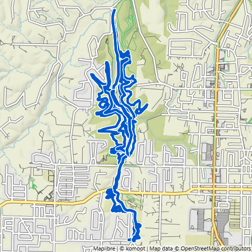
Coler Preserve
~16 miles (11+ hike-friendly) · paved greenway + natural surface · Owned & operated by the Peel Compton Foundation
A purpose-built mountain-bike preserve just west of downtown Bentonville, Coler is the most bike-forward system on this list—but there’s more here for hikers than you’d expect. A paved greenway runs through the preserve for an easy 5-mile out-and-back walk, and the paved Pedal Assist adds another gentle option. Among the natural-surface trails, about 11 hikeable miles stand out—the long green Esther’s (4 miles) and Oscar’s Loop (3 miles) are the big draws, with Good Vibrations, Copper Head, and Here’s Johnny rounding things out. Cap it off at Airship Coffee at The Homestead, a micro-café tucked into the woods.

Crystal Bridges & Compton Gardens Trails
~5 miles · paved + natural surface · Owned & operated by Crystal Bridges Museum of American Art & the Peel Compton Foundation
Not a mountain-bike system at all, but one of the most beautiful and accessible places to walk in Bentonville—and every trail here is open to hikers. The paved Razorback Greenway runs right through, linking the grounds of the Crystal Bridges Museum of American Art with historic Compton Gardens & Arboretum. From there, nearly 5 miles of the museum’s own trails branch off through Ozark woods and world-class outdoor art: the paved Art Trail (an open-air art tour connecting to Compton Gardens), the Orchard Trail to the museum entrance, and the wooded Tulip Tree trail. A little urban, a lot of beauty, and welcoming to every ability.

Handcut Hollow
~16 miles (13+ hike-friendly) · natural surface · Owned & operated by the Trailblazers
A compact, super-fun system tucked into a wooded hollow on the north edge of Bentonville, Handcut Hollow packs a lot of hikeable trail into a small footprint—and true to its name, its hand-cut tread drains well after rain. A handful of bike-only trails branch off the central hub, but nearly everything else is open to hikers, with lots of great loops to link together. Don’t miss Zone 4—a challenging, beautiful climb and the standout hike here—while the long Traverse Loop anchors the system for anyone wanting more distance.

Osage Park
compact — up to a ~4-mile loop · paved + boardwalk, nearly flat · Owned by the City of Bentonville, operated by the Peel Compton Foundation
The most accessible spot on this whole list—a flat oasis of paved paths and floating boardwalks winding through restored Ozark wetlands in the heart of Bentonville, with open views that feel a world away from downtown. There’s virtually no elevation and nothing off-limits to hikers, so it’s ideal for strollers, wheelchairs, and first-time walkers. The path network is compact, but weave it together and you can stitch a 4-mile “spaghetti loop” without ever leaving the park.

Slaughter Pen + Park Springs
30+ miles (20+ hike-friendly) · paved greenway + natural surface · Owned & operated by the Trailblazers & the City of Bentonville
Bentonville’s original trail system, spilling right out of downtown near Crystal Bridges and Compton Gardens. It’s the busiest, most urban system on this list—more than 30 miles of trail woven through Ozark woods, public art, and purpose-built bike features, with the paved Razorback Greenway running straight through as an easy, accessible spine. Plenty of it is built for bikes, but more than 20 of those miles are hike-friendly. Medusa and Tatamagouche, linked together, make a great moderate hike, and over on the Park Springs side, Black Apple Creek and Burns Arboretum are beautiful moderate walks—especially in spring and summer. Because so many trails here are bike-specific, the archive page maps exactly which ones are best on foot.
Ready to get out there?
Not sure which system fits you? Find a Hiking Route—filter by distance and difficulty.
First time on NWA trails? Getting Started on NWA Trails—what to bring, what to expect, and how to share the trail.