How to start hiking in Northwest Arkansas.

Which trails to hike at Handcut Hollow—and which not to
This is every trail in the system, all 21 of them. If you are putting together your own route, stay on the ones in the “Good to Hike” list.
Good to hike
12 trails
Hike any of these
- Checks in the Mail
- Do the Circulation
- Elbow Room
- Gravel Connector Beginner Trail
- Hand-cut Hollow XC Trail
- Mother Necessity
- Traverse Loop
- Traverse Loop Advanced
- Zone 1
- Zone 2
- Zone 3
- Zone 4
Don’t hike
9 trails
Don’t hike any of these
- Conjunction Junction
- Interplanet Janet
- My Hero Zero
- No More Kings
- Ready or Not
- Rushing Roulette
- School House Rock
- The Body Machine
- Victim of Gravity
A trail lands on the don’t hike list for one of three reasons. Some are posted bike-only, and that is almost always because of what the trail is—a gravity or downhill line where the traffic moves one way and moves fast. Others are technically open to foot traffic, but due to the nature of the trail, putting hikers and bikers on the trail together is dangerous, so avoiding them is our recommendation. And a few are perfectly fine to hike but sit off on their own or run only a few hundred feet, so there is no real sense in hiking them.
Heading to another system? You can see every trail we have mapped in one place.
Too many options? Filter these by distance & difficulty →

Handcut Hollow @ J St to Short Traverse Loop
1.91 mi · 175 ft gain · 92 ft/mi · Loop · Bentonville

Handcut Hollow @ the Schoolhouse to Sufferin' & Zones
2.57 mi · 375 ft gain · 146 ft/mi · Loop · Bentonville

Handcut Hollow @ the Schoolhouse to Traverse & Checks
3.67 mi · 275 ft gain · 75 ft/mi · Loop · Bentonville

Handcut Hollow @ the Schoolhouse to Sufferin', Traverse, Checks & Mother Necessity
4.02 mi · 350 ft gain · 87 ft/mi · Loop · Bentonville

Handcut Hollow @ the Schoolhouse to Sufferin', Traverse Advanced, Checks & Mother Necessity
4.14 mi · 325 ft gain · 79 ft/mi · Loop · Bentonville

Handcut Hollow @ J St. to Zones, Sufferin', Checks & Traverse
4.36 mi · 300 ft gain · 69 ft/mi · Loop · Bentonville

Handcut Hollow @ the Schoolhouse to Mother Necessity, Zones & Traverse Advanced
4.71 mi · 425 ft gain · 90 ft/mi · Loop · Bentonville
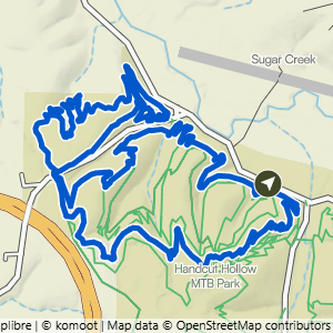
Handcut Hollow @ the Schoolhouse to Mother Necessity, Checks & Traverse Advanced
4.92 mi · 375 ft gain · 76 ft/mi · Loop · Bentonville

Handcut Hollow @ J St. to Traverse, Up the Zones & Suffering
5.1 mi · 475 ft gain · 93 ft/mi · Loop · Bentonville

Handcut @ Grammercy to Traverse, Checks & Advanced Traverse
6.25 mi · 400 ft gain · 64 ft/mi · Lollipop · Bentonville

Handcut Hollow @ the Schoolhouse to Mother Necessity, Checks, Traverse Advanced & Sufferin'
6.4 mi · 500 ft gain · 78 ft/mi · Loop · Bentonville

Handcut Hollow @ J St. to Advanced Traverse & Zones+
6.9 mi · 525 ft gain · 76 ft/mi · Loop · Bentonville