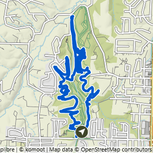
Coler Preserve

16 routes

Coler Preserve trail map

Which trails to hike or avoid

This is every trail in Coler Preserve, all 35 of them. If you are putting together your own route, stay on the ones in the “Good to Hike” list.

Good to hike 21 trails

Hike any of these
  • Angel Fall's Access
  • Applegate Trail
  • Copperhead Road
  • Esther's
  • Family Flow Return
  • Good Vibrations
  • Here's Johnny
  • Homestead Lane Connector
  • Hors d'Oeuvres
  • Lor-Axe
  • Meh Way to Cafe
  • Northwest Homestead Lane
  • Oscar's Loop
  • Pedal Assist
  • Rock Solid-Soft
  • The Grouch
  • The Platform
  • The Rise
  • Up Thunder Dome
  • Walton - Coler Creek Sidepath
  • Water Tower Access

Don’t hike 14 trails

Don’t hike any of these
  • Cease and Desist
  • Cleared for Take-Off
  • Dirt Therapy
  • Dirt Therapy Bridge
  • Drop the Hammer
  • Family Flow
  • Fire Line
  • Hard Way to Cafe
  • Rock Salad
  • Rock Soft
  • Rock Solid
  • Thunder Dome Left
  • Thunder Dome Right
  • Thunder Rolls

A trail lands on the don’t hike list for one of three reasons. Some are posted bike-only, and that is almost always because of what the trail is—a gravity or downhill line where the traffic moves one way and moves fast. Others are technically open to foot traffic, but due to the nature of the trail, putting hikers and bikers on the trail together is dangerous, so avoiding them is our recommendation. And a few are perfectly fine to hike but sit off on their own or run only a few hundred feet, so there is no real sense in hiking them.

Heading to another system? You can see every trail we have mapped in one place.

Routes at Coler PreserveFilter

Route map for Coler South to Lor-Axe West, a 2.2-mile easy hike in Bentonville, Arkansas

Coler South to Lor-Axe West

2.2 mi · 100 ft gain · 45 ft/mi · Lollipop · Bentonville

This route includes about .5 miles on the paved Applegate Trail.
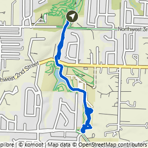
Route map for Coler South to Lor-Axe South, a 2.3-mile moderate hike in Bentonville, Arkansas

Coler South to Lor-Axe South

2.26 mi · 100 ft gain · 44 ft/mi · Lollipop · Bentonville

This route includes about 1 mile on the paved Applegate Trail.

Route map for Coler South to Coler North, a 3-mile paved walk in Bentonville, Arkansas

Coler South to Coler North

2.99 mi · 75 ft gain · 25 ft/mi · Out & Back · Bentonville
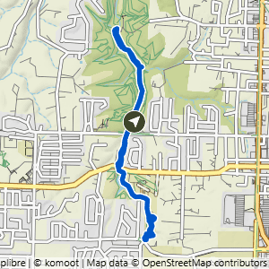
Route map for Coler South to Lor-Axe South & Good Vibrations, a 3.7-mile moderate hike in Bentonville, Arkansas

Coler South to Lor-Axe South & Good Vibrations

3.72 mi · 150 ft gain · 40 ft/mi · Lollipop · Bentonville

This route includes about 2.2 miles on the paved Applegate Trail.

Route map for Coler South to Here’s Johnny & Copperhead, a 3.8-mile challenging hike in Bentonville, Arkansas
Route map for Coler South to Esther’s Loop, a 3.9-mile easy hike in Bentonville, Arkansas

Coler South to Esther's Loop

3.93 mi · 225 ft gain · 57 ft/mi · Loop · Bentonville

This route includes about .3 miles on paved trail.

Route map for Coler South to Lor-Axe West & South, a 4-mile moderate hike in Bentonville, Arkansas

Coler South to Lor-Axe West & South

3.97 mi · 175 ft gain · 44 ft/mi · Lollipop · Bentonville

This route includes about 1 mile on the paved Applegate Trail.

Route map for Coler South to Full Esthers, a 4.2-mile easy hike in Bentonville, Arkansas

Coler South to Full Esthers

4.18 mi · 250 ft gain · 60 ft/mi · Loop · Bentonville

Route map for Coler South to Here’s Johnny, Copperhead & Oscar’s, a 4.6-mile challenging hike in Bentonville, Arkansas
Route map for Coler South to Full Applegate, a 5-mile paved walk in Bentonville, Arkansas

Coler South to Full Applegate

4.95 mi · 200 ft gain · 40 ft/mi · Out & Back · Bentonville

Route map for Coler South to Lor-Axe, Oscar’s & Copperhead, a 5.7-mile challenging hike in Bentonville, Arkansas

Coler South to Lor-Axe, Oscar's & Copperhead

5.69 mi · 300 ft gain · 53 ft/mi · Loop · Bentonville

Rock Obstacles
Route map for Coler South to Oscar’s, Esther’s & Here’s Johnny, a 5.8-mile challenging hike in Bentonville, Arkansas

Coler South to Oscar's, Esther's & Here's Johnny

5.79 mi · 350 ft gain · 60 ft/mi · Loop · Bentonville

Avoid After Rain
Route map for Coler South to Full Esthers, Oscars & Copperhead, a 6.2-mile challenging hike in Bentonville, Arkansas
Route map for Coler South Loop, a 7.6-mile challenging hike in Bentonville, Arkansas

Coler South Loop

7.59 mi · 425 ft gain · 56 ft/mi · Loop · Bentonville

This route includes about .9 miles on the paved Applegate Trail.

Route map for Coler South to Lor-Axe, Oscar’s, Copperhead & Here’s Johnny, an 8.9-mile challenging hike in Bentonville, Arkansas

Coler South to Lor-Axe, Oscar's, Copperhead & Here's Johnny

8.91 mi · 475 ft gain · 53 ft/mi · Loop · Bentonville

Avoid After Rain Rock Obstacles

Avoid this route after rain or in high humidity (like over 80%) as the wood features on Here's Johnny become extremely slippery.
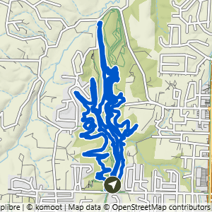
Route map for Coler South to Oscar’s, Copperhead & Esther’s, a 10.1-mile challenging hike in Bentonville, Arkansas

Coler South to Oscar's, Copperhead & Esther's

9.99 mi · 525 ft gain · 53 ft/mi · Loop · Bentonville

This route includes about 1.3 miles on the paved Applegate Trail.