How to start hiking in Northwest Arkansas.
Back 40 · Bella Vista
Power Station Loop South
Challenging
The route
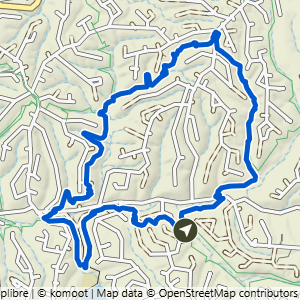
This route is part of the Back 40 trail system. Open the full turn-by-turn map, elevation profile, and offline download in Komoot.


Where to park
Power Station
Address
Power station, 9 Weybridge Dr, Bella Vista, AR 72714Google code is FRG4+G5C Bella Vista, AR
Open trailhead in Google MapsParking Area
small, gravel
Amenities
no restroom facilities
What to expect
Challenging routes like this one include natural-surface trails that are often only 1 foot wide (or narrower) and have steep slopes with significant climbs and descents (15% grade or more). Frequent obstacles may include rocks and roots 15 inches high or taller. Hikers must have excellent stability.
More routes from this trailhead
5 other routes start from Power Station.

Power Station to Back 40 Taylor
2.21 mi · 150 ft gain · 68 ft/mi · Out & Back · Bella Vista

Power Station to Sister Ledges
3.65 mi · 200 ft gain · 55 ft/mi · Out & Back · Bella Vista

Power Station to Double Ledges Loop
5.08 mi · 325 ft gain · 64 ft/mi · Loop · Bella Vista
Power Station to Taylor Homestead & SBAT Loop
5.37 mi · 425 ft gain · 79 ft/mi · Loop · Bella Vista

Power Station to Double Ledges Lollipop
5.75 mi · 350 ft gain · 61 ft/mi · Lollipop · Bella Vista