How to start hiking in Northwest Arkansas.

Address
Power station, 9 Weybridge Dr, Bella Vista, AR 72714 (Or type FRG4+G5C Bella Vista, AR directly into Google Maps.)
Get Directions to the TrailheadParking Area
small, gravel
Amenities
no restroom facilities
Routes starting from this location

Power Station to Back 40 Taylor
2.21 mi · 150 ft gain · 68 ft/mi · Out & Back

Power Station to Sister Ledges
3.65 mi · 200 ft gain · 55 ft/mi · Out & Back

Power Station to Double Ledges Loop
5.08 mi · 325 ft gain · 64 ft/mi · Loop
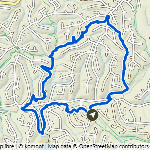
Power Station to Taylor Homestead & SBAT Loop
5.37 mi · 425 ft gain · 79 ft/mi · Loop

Power Station to Double Ledges Lollipop
5.75 mi · 350 ft gain · 61 ft/mi · Lollipop

Power Station Loop South
8.92 mi · 650 ft gain · 73 ft/mi · Loop