How to start hiking in Northwest Arkansas.
Back 40 · Bella Vista
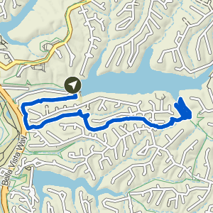
Pinion Creek Falls to Bella Vista Community Church
Moderate Waterfall
The route
Pinion Creek Falls is right next to the trailhead.
This route is part of the Back 40 trail system. Open the full turn-by-turn map, elevation profile, and offline download in Komoot.


Where to park
Pinion Creek Falls Trailhead
Address
Pinion Dr, Bella Vista, AR 72714Google code is FQF8+32R Bella Vista, AR
Open trailhead in Google MapsParking Area
small, gravel pull-off
Amenities
no restroom facilities; a portable toilet is available on top of the dam at the far end, but parking is restricted on the dam so you need to walk there.
What to expect
Moderate routes like this one include natural-surface trails that are often about 2 feet wide. The trails can have moderate slopes/inclines, with some sections being quite steep. Obstacles may include rocks and roots up to about 8 inches high, so hikers should have good stability.
More routes from this trailhead
6 other routes start from Pinion Creek Falls Trailhead.

Pinion Creek Falls to Trafalgar on Back 40
1.65 mi · 50 ft gain · 30 ft/mi · Out & Back · Bella Vista
Pinion Creek Falls is right next to the trailhead.

Pinion Creek Falls to Trafalgar
1.69 mi · 100 ft gain · 59 ft/mi · Out & Back · Bella Vista
Pinion Creek Falls is right next to the trailhead.

Pinion Creek Falls to Lancashire
1.94 mi · 175 ft gain · 90 ft/mi · Out & Back · Bella Vista
Pinion Creek Falls is right next to the trailhead.

Pinion Creek Falls to It'll Bluff Out Lollipop
3.19 mi · 200 ft gain · 63 ft/mi · Lollipop · Bella Vista
Pinion Creek Falls is right next to the trailhead.

Pinion Creek Falls to Back 40 & Tip of the Spear
5.38 mi · 425 ft gain · 79 ft/mi · Lollipop · Bella Vista
Pinion Creek Falls is right next to the trailhead.
Pinion Creek Falls to Tip of the Spear
5.42 mi · 475 ft gain · 88 ft/mi · Lollipop · Bella Vista
Pinion Creek Falls is right next to the trailhead.