How to start hiking in Northwest Arkansas.
Metfield Skills Park
Parking for Back 40 · Bella Vista, AR
Metfield Park is a Bella Vista recreation park with pickleball courts and the Metfield Skills Park for bikes. Its large lot and restrooms make it an easy way into the Back 40, and routes from here run from about 2 miles to 10.
Where to Park

Address
Metfield Skills Park, 49 Commonwealth Rd, Bella Vista, AR 72714 (Or type FR43+822 Bella Vista, AR directly into Google Maps.)
Get Directions to the TrailheadParking Area
large, paved
Amenities
full restrooms

Metfield to Trafalgar on Rago
2.26 mi · 175 ft gain · 77 ft/mi · Out & Back

Metfield to Merritt Dr.
2.91 mi · 125 ft gain · 43 ft/mi · Out & Back

Metfield to Greenway & Rago Lollipop
3.22 mi · 150 ft gain · 47 ft/mi · Lollipop
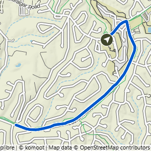
Metfield to Watson Dr.
3.36 mi · 150 ft gain · 45 ft/mi · Out & Back
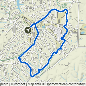
Metfield to Happy Hour Loop
5.46 mi · 300 ft gain · 55 ft/mi · Loop

Metfield to Blowing Springs
6.02 mi · 275 ft gain · 46 ft/mi · Out & Back

Metfield to Lambeth
6.42 mi · 300 ft gain · 47 ft/mi · Out & Back

Metfield to Rago Loop
6.83 mi · 525 ft gain · 77 ft/mi · Loop

Metfield to Happy Hour Loop & Snowbird
7 mi · 375 ft gain · 54 ft/mi · Loop

Metfield to Rago, Pinyon Creek & Ledges
8.91 mi · 650 ft gain · 73 ft/mi · Loop

Metfield Big Loop South
10.01 mi · 725 ft gain · 72 ft/mi · Loop