How to start hiking in Northwest Arkansas.
Bella Vista Museum
Parking for Back 40 · Bella Vista, AR
The Bella Vista Historical Museum tells the story of Bella Vista, and its lot is a trailhead for the Back 40. The museum is free and open Wednesday through Sunday afternoons, with restrooms inside when it’s open. Routes from here run from under a mile to more than 10, including one to the Lake Rayburn waterfall. The waterfall only flows after good rain, so plan that hike after a wet spell.
Where to Park

Parking Note
The museum is open Wednesday through Sunday, 1–5 p.m. Please park somewhere else during those hours.
Address
Bella Vista Historical Museum, 1885 Bella Vista Way, Bella Vista, AR 72714 (Or type FQ64+J9P Bella Vista, AR directly into Google Maps.)
Get Directions to the TrailheadParking Area
medium, paved
Amenities
full restrooms available inside the museum when it's open.

Bella Vista Museum to Lake Rayburn Waterfall
0.6 mi · 50 ft gain · 83 ft/mi · Loop
Depending on the amount of recent rain, the waterfall may be too deep to safely cross without getting your shoes very wet.
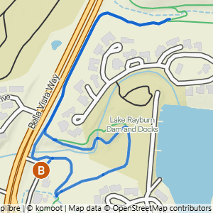
Bella Vista Museum to It'll Bluff Out Shortcut & Lake Rayburn Waterfall
1.17 mi · 100 ft gain · 85 ft/mi · Lollipop

Bella Vista Museum to It'll Bluff Out & Lake Rayburn Waterfall
2.01 mi · 150 ft gain · 75 ft/mi · Lollipop

Bella Vista Museum to It'll Bluff Out South & Dalton Dr.
2.79 mi · 100 ft gain · 36 ft/mi · Out & Back

Bella Vista Museum to Pinion Creek Falls
3.22 mi · 175 ft gain · 54 ft/mi · Lollipop

Bella Vista Museum to Buckingham
3.77 mi · 300 ft gain · 80 ft/mi · Out & Back
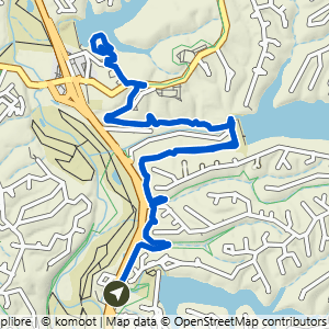
Bella Vista Museum to Cooper Chapel
5.99 mi · 425 ft gain · 71 ft/mi · Lollipop

Bella Vista Museum to It'll Bluff Out South
6.18 mi · 450 ft gain · 73 ft/mi · Out & Back

Bella Vista Museum to Lancashire on It'll Bluff Out
6.44 mi · 475 ft gain · 74 ft/mi · Lollipop

Bella Vista Museum to Tip of the Spear
6.56 mi · 575 ft gain · 88 ft/mi · Lollipop

Bella Vista Museum Loop East
10.2 mi · 900 ft gain · 88 ft/mi · Loop