How to start hiking in Northwest Arkansas.
Route
Little Sugar · Bella Vista
Scotsdale to Forest Hills
Moderate
The route
- Trail system
- Little Sugar
- Trailhead
- Scotsdale Trailhead
- Distance
- 4.44 miles
- Elevation gain
- 325 feet (73 feet per mile)
- Shape
- Out and back. You turn around at the far end and return the same way.
- Surface
- Natural surface the whole way
- Difficulty
- Moderate. A route is rated by its most difficult section. This route may include natural-surface trails that are often about 2 feet wide. The trails can have moderate slopes/inclines, with some sections being quite steep. Obstacles may include rocks and roots up to about 8 inches high, so hikers should have good stability. See examples of moderate trails

Start hiking
Navigate with Komoot
Prefer a different app?
Komoot shows the turn-by-turn route, the elevation profile, and your spot on the trail. A free account is all you need, and you can download the route to use without cell service. New to Komoot? See how it works.
- Open the route in Komoot.
- Tap the three dots at the top right, then Download GPX file.
- Open the file in your favorite hiking app, like Trailforks, AllTrails, Gaia GPS, or Garmin Connect.
Where to park

Where to park
Scotsdale Trailhead
Address
Little Sugar Trails Trailhead - Scotsdale Dr, Cullen Hills Dr, Bella Vista, AR 72715Google code is FPQ2+4W Bella Vista, AR
Open trailhead in Google MapsParking Area
large, paved
Amenities
no restroom facilities

Scotsdale to the Bridge
2.19 mi · 125 ft gain · 57 ft/mi · Out & Back · Bella Vista

Scotsdale to Technical Difficulty
3.38 mi · 175 ft gain · 52 ft/mi · Lollipop · Bella Vista

Scotsdale to Scalloway
3.72 mi · 350 ft gain · 94 ft/mi · Out & Back · Bella Vista

Scotsdale to Technical Difficulty+
4.56 mi · 250 ft gain · 55 ft/mi · Lollipop · Bella Vista

Scotsdale to Sherlock
5.37 mi · 500 ft gain · 93 ft/mi · Out & Back · Bella Vista
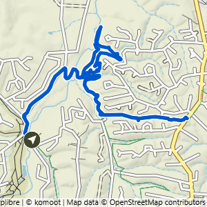
Scotsdale to Technical Difficulty & Tunnel Vision
5.8 mi · 400 ft gain · 69 ft/mi · Lollipop · Bella Vista