How to start hiking in Northwest Arkansas.
Blowing Springs Trailhead
Parking for Blowing Springs · Bella Vista, AR
The Blowing Springs Trailhead is at Blowing Springs Park in Bella Vista, home to a campground and the Blowing Springs trails. The Gear Garden is a short walk east. Routes from here run from about 2 to 7 miles, from paved Greenway walks to challenging trail.
Where to Park

Address
Blowing Springs MTB Trail Head/Back 40, 651 Blowing Spring Rd, Bella Vista, AR 72714 (Or type CQRC+627 Bella Vista, AR directly into Google Maps.)
Get Directions to the TrailheadParking Area
large, paved
Amenities
portable toilet

Blowing Springs to Blowing Springs North & Bomb Diggity
2.11 mi · 150 ft gain · 71 ft/mi · Loop
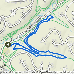
Blowing Springs to Low Ride
2.12 mi · 175 ft gain · 83 ft/mi · Loop

Blowing Springs to West Euston
2.14 mi · 100 ft gain · 47 ft/mi · Out & Back

Blowing Springs to Low Ride & Blowing Springs North
2.69 mi · 225 ft gain · 84 ft/mi · Loop

Blowing Springs to Mighty Pine
3.06 mi · 300 ft gain · 98 ft/mi · Loop

Blowing Springs to Mighty Pine
3.27 mi · 325 ft gain · 99 ft/mi · Loop

Blowing Springs South & Back 40
3.34 mi · 200 ft gain · 60 ft/mi · Loop

Blowing Springs to Bomb Diggity, Back 40 & Low Ride
3.35 mi · 250 ft gain · 75 ft/mi · Loop

Blowing Springs to Sally, Smuggler's & All-American
3.36 mi · 250 ft gain · 74 ft/mi · Lollipop
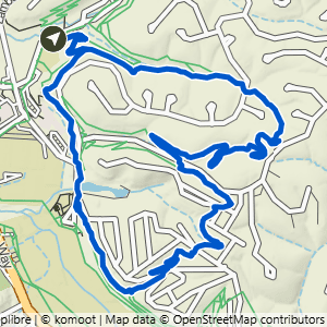
Blowing Springs to Rabbit Hole & Mighty Pine
3.88 mi · 375 ft gain · 97 ft/mi · Loop

Blowing Springs to Low Ride & Mighty Pine
3.9 mi · 375 ft gain · 96 ft/mi · Loop

Blowing Springs to It'll Bluff Out
4.48 mi · 400 ft gain · 89 ft/mi · Out & Back

Blowing Springs to Low Ride, Cooper & Mighty Pine
4.48 mi · 400 ft gain · 89 ft/mi · Lollipop

Blowing Springs to Bomb Diggity, It'll Bluff Out, Disco Stu & Blowing Springs North
5.66 mi · 500 ft gain · 88 ft/mi · Lollipop

Blowing Springs to It'll Bluff Out at Kingsland
6.94 mi · 500 ft gain · 72 ft/mi · Out & Back