How to start hiking in Northwest Arkansas.
Bella Vista Community Church
Parking for Back 40 · Bella Vista, AR
This trailhead is the large paved lot at Bella Vista Community Church, on the Back 40. There are no restrooms here. Routes from here run from about 3 to 7 miles and are rated moderate or challenging.
Where to Park

Address
Bella Vista Community Church, 75 E Lancashire Blvd, Bella Vista, AR 72714 (Or type FQH7+467 Bella Vista, AR directly into Google Maps.)
Get Directions to the TrailheadParking Area
large, paved
Amenities
no restroom facilities

Bella Vista Community Church to Pinion Creek Falls
3.21 mi · 225 ft gain · 70 ft/mi · Out & Back
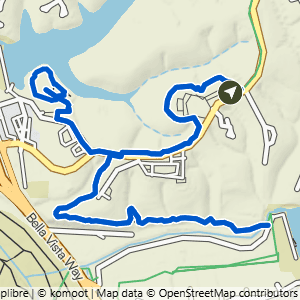
Bella Vista Community Church to Cooper Chapel & Pinion Creek Falls
4.1 mi · 275 ft gain · 67 ft/mi · Lollipop

Bella Vista Community Church to Pinion Creek Falls & Lookout+
4.87 mi · 325 ft gain · 67 ft/mi · Out & Back

Bella Vista Community Church to Cooper Chapel & Lookout
4.96 mi · 350 ft gain · 71 ft/mi · Lollipop

Bella Vista Community Church to the Cave
6.57 mi · 525 ft gain · 80 ft/mi · Out & Back
The trail down to Bear Hollow Cave is extremely steep.

Bella Vista Community Church to the Cave & Mildenhall
6.94 mi · 575 ft gain · 83 ft/mi · Out & Back
The trail down to Bear Hollow Cave is extremely steep.