Hiking 101 Class in Bella Vista · Sat, Oct 17 · 8–10 AM · Free · Get your ticket →Hiking 101 Class in Bella Vista · Oct 17 · Free · Tickets →
How to start hiking in Northwest Arkansas.
Route
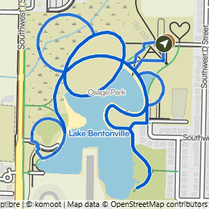
Osage Park · Bentonville
Osage Park 2.6
Paved
2.63Miles
0Feet of gain
0Feet per mile
LollipopRoute type
The route
- Trail system
- Osage Park
- Trailhead
- Osage Park
- Distance
- 2.63 miles
- Elevation gain
- 0 feet (0 feet per mile)
- Shape
- Lollipop. You hike out, go around a loop, then return the way you came. (A more complicated lollipop can mix several loops and out-and-backs.)
- Surface
- Paved the whole way
- Difficulty
- Paved. A route is rated by its most difficult section. This route may include smooth, hard-surface paths that are typically 6 feet or more wide, with no rocks or roots to navigate. The slope of the trail can vary, with some being nearly flat and others having noticeable inclines and hills. See examples of paved trails

Start hiking
Navigate with Komoot
Prefer a different app?
Komoot shows the turn-by-turn route, the elevation profile, and your spot on the trail. A free account is all you need, and you can download the route to use without cell service. New to Komoot? See how it works.
- Open the route in Komoot.
- Tap the three dots at the top right, then Download GPX file.
- Open the file in your favorite hiking app, like Trailforks, AllTrails, Gaia GPS, or Garmin Connect.
Where to park

Where to park
Osage Park
Address
700 SW 16th St, Bentonville, AR 72712Google code is 9Q4M+3F3 Bentonville, AR
Open trailhead in Google MapsParking Area
large, paved
Amenities
full restrooms

Osage Park 1.9
1.89 mi · 0 ft gain · 0 ft/mi · Lollipop · Bentonville
Osage Park 4
4 mi · 25 ft gain · 6 ft/mi · Lollipop · Bentonville