How to start hiking in Northwest Arkansas.
Route
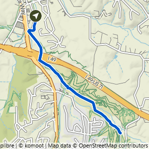
Slaughter Pen + Park Springs · Bentonville
Blue Hole to mid-Slaughter Pen
Paved
The hardest parts of this route are 17 Paved sections, 2.0 mi in all.
A section is the stretch of trail between two junctions. Each section is rated by its hardest spot, so a Challenging section may be mostly easy walking with only a few feet of steep or rocky ground.
Point to a color in the bar, or tap it, to see its sections on the trail map.
The route
- Trail system
- Slaughter Pen + Park Springs
- Trailhead
- Blue Hole Parking Area
- Distance
- 4.00 miles
- Elevation gain
- 125 feet (31 feet per mile)
- Shape
- Out and back. You turn around at the far end and return the same way.
- Surface
- Paved the whole way
- Difficulty
- Paved. A route is rated by its most difficult section. Routes marked PAVED stay on smooth, hard surfaces like asphalt or concrete, with no rocks or roots underfoot. They are the most accessible routes in our library and usually work well for strollers, wheelchairs, and anyone new to walking and hiking. A few paved routes include stairs or steep stretches, and those are noted on their route cards. See examples of paved trails
Start hiking
Navigate with Komoot
Prefer a different app?
Komoot shows the turn-by-turn route, the elevation profile, and your spot on the trail. A free account is all you need, and you can download the route to use without cell service. New to Komoot? See how it works.
- Open the route in Komoot.
- Tap the three dots at the top right, then Download GPX file.
- Open the file in your favorite hiking app, like Trailforks, AllTrails, Gaia GPS, or Garmin Connect.
Where to park

Where to park
Blue Hole Parking Area
Address
Blue Hole Parking Area, Bentonville, AR 72712Google code is CQCH+HM8 Bentonville, AR
Open trailhead in Google MapsParking Area
Medium, Paved
Amenities
no restroom facilities
Trails You’ll Hike
Tap a trail to see a photo preview of the whole trail.
 PavedBlue Hole to Slaughter Pen2.61 mi · 100 ft gain · 38 ft/mi · Lollipop
 PavedBlue Hole to Slaughter Pen on Greenway2.65 mi · 100 ft gain · 38 ft/mi · Out & Back
 PavedBlue Hole to Boneyard on Greenway4.7 mi · 125 ft gain · 27 ft/mi · Out & Back
 PavedBlue Hole to Cub Circle on Greenway5.86 mi · 175 ft gain · 30 ft/mi · Out & Back