• Skip to main content
Hiking 101 Class in Bella Vista · Sat, Oct 17 · 8–10 AM · Free · Get your ticket →Hiking 101 Class in Bella Vista · Oct 17 · Free · Tickets →

Hike NWA

How to start hiking in Northwest Arkansas.

  • Home
  • Explore
    • Bella Vista
    • Bentonville
    • Trail Systems
    • Trail Map
    • Trail List
    • Trailheads
    • Trail Difficulty
    • Trail Surfaces
  • Plan
    • Getting Started
    • Route Library
    • Hikeable Trails
    • Beginner Hikes
    • FAQs
  • Guides
    • Before You Hike
    • Clothing & Gear
    • Staying Safe
    • On the Trail
  • About
    • Our Team
    • Contact
  • Get Involved
    • Join a Group Hike
    • Lead a Hike
    • Donate
  • Find Routes
Home/Hiking Guides/Staying Safe/Hiking Safety in Northwest Arkansas

Hiking Safety in Northwest Arkansas

Day hiking here is low-risk—but the Ozarks have their own particular hazards, and they are probably not the ones you’re picturing. The things that actually go wrong on Bella Vista and Bentonville trails are heat, ticks, and footing. Bears and snakes make better stories, but they send far fewer people home early. This guide covers what to prepare for, in roughly the order it matters.
On this pageHeat and WaterWhat to WearPlants to KnowTicks and Biting InsectsSnakes and WildlifePacing YourselfBefore You GoWhere to Next?More Guides
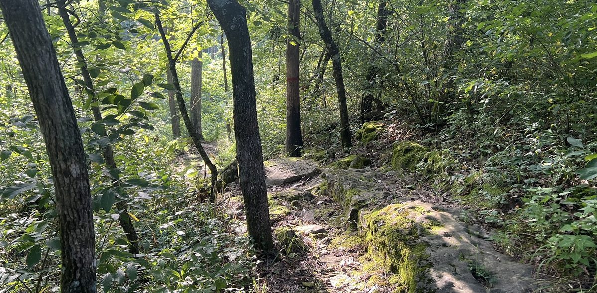
A hiker wearing a backpack on a narrow wooded trail past moss-covered rocks

Heat and Water

If you take one thing from this page, take this one. Arkansas summers combine real heat with humidity high enough that sweat stops cooling you efficiently, and that combination is what turns a pleasant two-hour hike into a genuinely bad afternoon. It is far and away the most common problem on our trails.

How much water to carry

  • At least 2 liters (about 68 oz) per person for a day hike, and more on hot or longer days. In serious heat, plan on roughly 8 oz or more per hour of walking.
  • Drink before you feel thirsty. Thirst is already a sign of mild dehydration, not a warning that arrives early.
  • Add electrolytes (tablets, powder, or a sports drink) on longer or hotter outings. In high humidity you lose more salt than plain water replaces.
  • Start the hike already hydrated. Drinking a bottle in the parking lot does not undo a morning of coffee.
  • Never drink untreated water from creeks or springs, however clear it looks. Waterborne illness is a real risk here, and our creeks drain a lot of pasture.

Hike around the heat, not through it

The simplest fix is timing. Start early in the morning or head out in the evening and skip the middle of the day entirely—roughly 10 a.m. to 4 p.m. is the stretch to avoid in summer. Shade helps enormously, and most of our trails have plenty of it, but shade is not air conditioning.

Know the warning signs

  • Dehydration—excessive thirst, dry mouth, headache, dizziness, reduced urine output. Stop, find shade, drink. More on dehydration from MedlinePlus.
  • Heat exhaustion—heavy sweating, weakness, nausea, headache, elevated heart rate. Stop hiking. Get to shade, cool down, drink, and end the hike—don’t push on to finish the loop. CDC on heat exhaustion.
  • Heat stroke is a medical emergency—confusion, hot skin that has stopped sweating, very high body temperature, loss of consciousness. Call 911, move the person into shade, and start cooling them immediately with whatever water you have. CDC on heat stroke.

What to Wear

Dress for the weather and for the environment—ticks, brush, and temperatures that swing more than you’d expect between a shaded hollow and an exposed ridge.

  • Skip cotton. Moisture-wicking synthetics or merino wool are much better. Cotton holds sweat, which leaves you clammy in summer and genuinely cold if the weather turns.
  • In warm months, go light-colored and loose. Light fabric reflects heat and makes ticks far easier to spot before they find skin.
  • Consider long pants even in summer. Plenty of experienced local hikers wear long pants and sleeves through July for tick and brush protection, and tuck their pants into their socks. It looks odd and it works.
  • Wear shoes with real tread. You don’t need boots for most of our trails, but you do need traction—Ozark rock gets slick when wet, and small water crossings are common. See what our trail surfaces actually look like.
  • Add a brimmed hat and sunglasses. Even on shaded trail there are exposed stretches, and the sun here is strong from spring through fall.
  • In winter, layer so you can adjust—a base layer, an insulating mid-layer, and a wind or rain shell. You will warm up fast on the first climb and cool down just as fast at the overlook.

Plants to Know

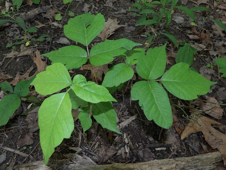
Poison ivy leaves in groups of three on the forest floor
Poison ivy. Leaves of three, glossy or dull, with smooth or lightly toothed edges.
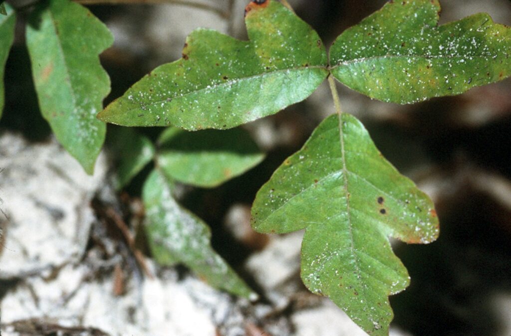
Eastern poison oak leaves in groups of three with rounded, lobed edges like an oak leaf
Eastern poison oak. Leaves of three with rounded lobes, like a small oak leaf.
  • Poison ivy is everywhere. It is extremely common along our trails, especially in moist ground and near creeks. “Leaves of three, let it be” is still the best rule. Note that the hairy vines climbing tree trunks are poison ivy too, and that dead vines in winter can still cause a reaction. Eastern poison oak is less common here but causes the same rash. It has the same three leaflets, with rounded lobes like an oak leaf.
  • Poison hemlock grows in the area. Look for small white umbrella-shaped flower clusters and smooth stems with purple blotches, usually in disturbed ground and along trail edges. It’s dangerous if any part of it is eaten, and the sap can irritate skin—so don’t pull it, snap it, or handle it, and keep children and dogs away from it.
  • Briars and brush are frequent on narrower trails, which is another argument for long pants.

The general habits that cover all of it—stay on marked trail where you can, wear long pants on overgrown routes, wash skin and clothing promptly when you get home, and if you don’t know what a plant is, just leave it alone.

Plant photos: poison ivy by Broly0 (CC0) and eastern poison oak by Robert H. Mohlenbrock, USDA (public domain), via Wikimedia Commons.

Ticks and Biting Insects
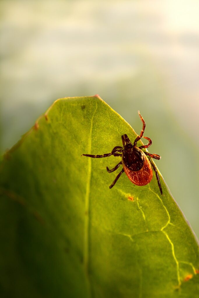
A tick perched on the edge of a green leaf, waiting for a host to brush past
Ticks wait on grass and low brush at the edge of the trail and grab on as you brush past.

Ticks are the most consequential hazard on this page after heat, and Northwest Arkansas is one of the worst places in the country for them. The aggressive lone star tick is active here from spring through fall and sometimes into mild winters, and it’s the species linked to alpha-gal syndrome—a red-meat allergy that Arkansas leads the nation in.

The short version of prevention:

  • Treat clothing and shoes with permethrin. This is the single most effective thing you can do, and it survives several washes. It goes on fabric, never on skin.
  • Use DEET or picaridin on exposed skin.
  • Stay out of tall grass and brush, and walk the middle of the trail rather than the edges.
  • Do a thorough tick check during and after every hike—scalp, behind the ears, waistband, armpits, and behind the knees.

Read the full guide to ticks and alpha-gal syndrome for how to remove an attached tick correctly, what symptoms to watch for afterward, and why alpha-gal matters so much here.

Other insects. Mosquitoes and chiggers are common in warm, humid conditions, and the same repellent and clothing habits handle both. Texas red-headed centipedes can deliver a painful sting, and black widow and brown recluse spiders are present—usually under rocks, logs, or loose bark. The habit that covers all three—don’t put your hands anywhere you can’t see.

Snakes and Wildlife

This is the section newcomers worry about most and need least. Serious wildlife incidents on NWA trails are rare, and nearly all of them come down to someone reaching where they couldn’t see or trying to handle an animal.

  • Snakes. Copperheads are the ones you’re most likely to meet, with timber rattlesnakes and—near water—cottonmouths also present. Most bites happen when someone steps on a snake or tries to move it. Watch where you put your feet and hands on rocky outcrops and in leaf litter, and step onto logs and rocks rather than over them so you can see the far side.
  • Black bears. Arkansas has a healthy population centered on the Ozarks and Ouachitas, but encounters are uncommon and bears generally want nothing to do with you. The real risk is surprising one, so make some noise in thick brush or near loud water. If you do see a bear, back away slowly, speak firmly, make yourself look big, and do not run.

Read the full guide to snakes, bears, and wildlife, including which snakes are actually venomous, how to tell them from the harmless ones you’ll see far more often, and correct snakebite first aid—much of what people “know” about it is wrong and makes things worse.

Pacing Yourself

Heat and humidity raise the physical cost of every mile. Your heart rate and your perceived effort both climb faster than they would on the same trail in October, which is why a route that felt easy in spring can feel punishing in July.

  • Take frequent short breaks in the shade—every 15 to 20 minutes in high heat, and more often on climbs.
  • Watch your effort, not just the distance. If you use a fitness watch or chest strap, a rough guide to your maximum heart rate is 220 minus your age, and you want to spend most of a hike comfortably below it. It’s a crude estimate that can be off by quite a bit for any individual, so treat how you actually feel as the better signal.
  • Adjust for yourself. Fitness, age, pre-existing conditions, and medications that affect heat tolerance all change what’s reasonable. Don’t push through significant discomfort—there’s no prize for finishing the loop.
  • Build in recovery. Hydration, electrolytes, and rest do most of the work. A few easy calf, groin, and hip stretches before and after a hike help too, particularly if you sit at a desk all week.

If you’re building up, our Beginner’s Guide sequences routes from paved paths through to the toughest trails in Bella Vista and Bentonville, so you can add difficulty a step at a time instead of all at once.

Before You Go

  • Check the forecast properly. Thunderstorms build fast here and bring lightning and flash-flood risk. After heavy rain, never cross a swollen stream—our creek crossings can go from ankle-deep to impassable in an hour.
  • Tell someone your plan—where you’re parking and roughly when you’ll be back.
  • Save your map offline. Cell service drops out in the hollows. How to use Komoot covers doing this properly.
  • Carry the basics—charged phone, water, a small first-aid kit, a whistle, a headlamp, snacks, and a layer.
  • Know where you’re parking. Trailheads: Where to Park to Hike maps the trailheads our routes start from, with each one’s parking size, surface, bathrooms, and directions.

Where to Next?

Getting Started on the TrailsIf this is your first hike here, start there.

Northwest Arkansas trails are rewarding when you respect the environment. Water, sensible clothes, an eye out for ticks and plants, and attention to what your body is telling you cover almost everything. Hike more. Live more.

This guide is general information from a volunteer trail organization, not medical advice. If you have a health condition, take medication, or are unsure whether a route suits you, talk to your doctor. See our Terms of Use and Trail Safety Disclaimer.

Read the Previous GuideWater, Electrolytes, and Trail SnacksClothing & Gear · 4 of 4 guidesRead the Next GuideTicks and Alpha-Gal Syndrome in Northwest ArkansasStaying Safe · 2 of 5 guides

More “Staying Safe” Guides

Ticks and Alpha-Gal Syndrome in Northwest ArkansasRead the guide Snakes, Bears, and Wildlife on Northwest Arkansas TrailsRead the guide How to Share Your Location on the TrailRead the guide Winter Hiking in Northwest ArkansasRead the guide

More Guide Categories

Before You HikeWhich trails you can hike, getting your body ready, and finding people to hike with.Clothing & GearClothes, shoes, water, snacks, and the gear worth carrying.On the TrailHow to share the trail, take care of it, and bring your dog along.

All Hiking Guides →

Explore & Plan a Hike

  • Bella Vista
  • Bentonville
  • Trail Systems
  • Trail Map
  • Trail List
  • Trailheads
  • Trail Difficulty
  • Trail Surfaces
  • Route Library
  • FAQs

Guides & Resources

  • Getting Started
  • Hiking Guides
  • Before You Hike
  • Clothing & Gear
  • Staying Safe
  • On the Trail
  • Beginner Hikes
  • How to Use Komoot
  • Bella Vista Walks & Hikes
  • Read the Community Fundamentals
  • Sign the Waiver

Hike NWA

  • About
  • Donate
  • Contact
  • Privacy Policy
  • Terms of Use
  • Donation Policy
  • Accessibility
  • Hike Lead Dashboard
  • Facebook
  • Instagram
  • Strava
  • Komoot

Copyright © 2026 · Hike NWA · A registered 501(c)(3) nonprofit organization
Mailing address: 412 Town Center NE #1044, Bella Vista, AR 72714 · EIN: 42-2911997

Powered by
Necessary cookies enable essential site features like secure log-ins and consent preference adjustments. They do not store personal data.
None
Functional cookies support features like content sharing on social media, collecting feedback, and enabling third-party tools.
None
Analytical cookies track visitor interactions, providing insights on metrics like visitor count, bounce rate, and traffic sources.
None
Advertisement cookies deliver personalized ads based on your previous visits and analyze the effectiveness of ad campaigns.
None
Unclassified cookies are cookies that we are in the process of classifying, together with the providers of individual cookies.
None
Powered by