Are you just starting to hike? Want to get familiar with the parking locations and the trails in Bella Vista and Bentonville? Need to build endurance and stamina to walk longer distances and over more difficult terrain?
How to Use this Guide
In this guide, you’ll find some hiking routes that will introduce you to all of the parking locations listed on hikenwa.org and take you progressively through hikes of increasing difficulty.
All of the hikes in this guide are about three miles or less, and they are listed in order of increasing difficulty, not necessarily distance.
The routes are divided into four levels—start at whichever level you’re most comfortable. Hike the routes in that level until you can do them comfortably, then move up to the next level. By the time you can comfortably hike all of Level 4, you’ll be ready to tackle any type of trail in Bella Vista and Bentonville at even greater distances. It’s also just fine to stop at the Level 3—that will still prepare you to hike the vast majority of our trails.
Level 1 — Paved
These paved routes are listed generally in order of difficulty based on length and elevation gain. Of all the routes, Branchwood Trail has the greatest noticeable elevation gain, and walking the loop twice will give you a pretty challenging 3-mile walk, preparing you very well for the Level 3 hikes that have a lot of elevation gain. This is the easiest way to get started building some stamina, but you can skip to Level 2 immediately if you’d like to get on the trails! View the Level 1 Hiking Guide
Level 2 — Easy
These routes are on unpaved trail (although a few have paved trails mixed in) with fairly easy terrain and less than 65 ft/mile of elevation gain. View the Level 2 Hiking Guide
Level 3 — Moderate
These routes have up to 110 ft/mile of elevation gain and tend to have more difficult, uneven terrain. Hiking at this level will prepare you to hike the vast majority of the trails in Bella Vista and Bentonville. View the Level 3 Hiking Guide
Level 4 — Challenging
Overall elevation gain doesn’t increase at this level, but these routes are significantly more challenging due to the increasingly uneven terrain that is significantly steeper at times. These routes may require you to hike/climb over rocks or other obstacles, all of which require much greater balance. This level will prepare you to hike any trail in Bella Vista and Bentonville. View the Level 4 Hiking Guide
Where to Park
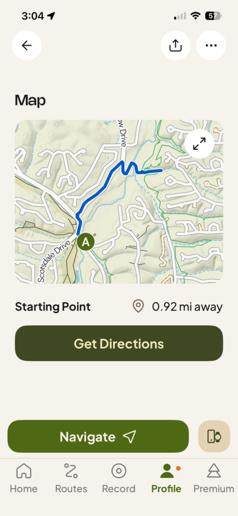
You’ll notice that the name of the route always begins with the name of the parking location (e.g., the route “Scotsdale to the Bridge” means you park at Scotsdale). But how do you get to Scotsdale if you don’t know where that is?
You have a couple of options.
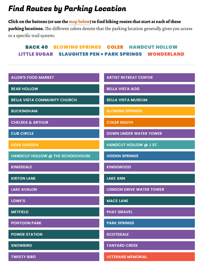
Find the Parking Location on HikeNWA.org
Visit the Find a Route page, click on the parking location you want, and you’ll open a page that lists all the information you need. You can either paste the alphanumeric code (e.g. FQH7+467 Bella Vista, AR) into Google Maps, or click the code link itself to load the directions in Google Maps.
Use the Komoot App
Open the route in the Komoot app, scroll down a bit, and you’ll see a button that says “Get Directions.” Click that button, and it’ll open your navigation app (like Google Maps) and take you directly to the parking location.